SaraniaSat’s Cloud‑Native AI/ML in Orbit Demonstration: Bridging Earth and Space with BruhnBruhn Innovation’s dacreo apto
August 11, 2025 – Salt Lake City, Utah
Introduction
On July 24, 2025, a unique international partnership of SaraniaSat, BruhnBruhn Innovation (BBI), NV5 Geospatial Software, Netnod, and Hewlett Packard Enterprise (HPE) brought true cloud-native computing to the International Space Station (ISS).
The ISS isn’t just home to astronauts—it’s one of the most versatile science labs ever built. Operated by NASA, ESA, JAXA, CSA, and Roscosmos, it serves as a National Laboratory where companies and researchers validate cutting-edge technologies in the real space environment. Our project grew from this opportunity: to show that cloud-native, Kubernetes-based applications can run reliably in orbit, delivering real-time insights directly from space.
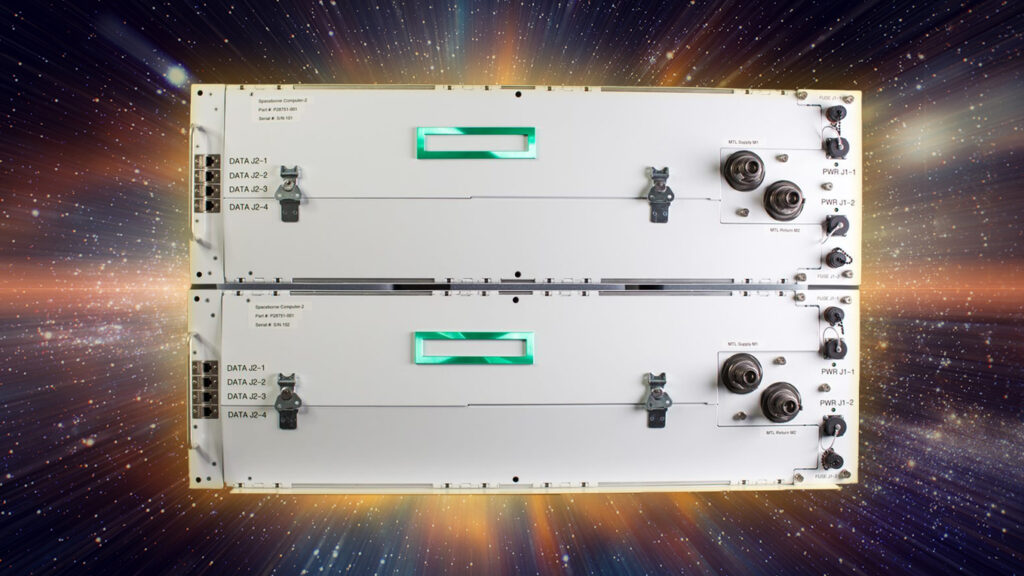
Picture of HPE’s Spaceborne Computer-2 on the International Space Station(Courtesy of HPE)
As humanity launches more sensors and satellites, the flood of Earth-observation and scientific data is overwhelming ground-centric systems. Waiting hours—or days—for raw imagery and telemetry to be downlinked, processed on Earth, and then sent back up introduces cost, latency, and limits on autonomy. From disaster response to on-orbit manufacturing, future missions demand immediate insights and self-healing operations that simply can’t wait for a round trip to the ground.
Edge computing in space solves this by processing large datasets directly aboard satellites, stations, or probes. But deploying off-the-shelf Kubernetes on standard Linux leaves critical gaps: cosmic rays can corrupt memory and crash containers, clocks drift apart and break secure connections, and any failed update can render a space asset unusable thousands of kilometers away.
From Idea to Orbit: A Back Story
Challenge
Data Deluge: A single MAXAR WorldView-3 multispectral data cube consisting of 8 bands can be ~1.5 GB. Transmitting that raw is slow, non-timely, not responsive and costly.
Operational Risk: Space hardware can’t be manually rebooted or reinstalled if software fails.
Standard Kubernetes: Does not have space hardening or space mission suitable services, for instance, typically lacking Delay Time Networking.
NV5 Geospatial Software delivered advanced image analytics through the ENVI suite.
Netnod secure, resilient networking architectures supporting dacreo apto development
BruhnBruhn Innovation created dacreo apto, a hardened, Kubernetes-compatible spacestack.
Validation on the International Space Station
Full-resolution multi-spectral satellite images were uplinked by HPE to the ISS using NASA TDRS network.
On-orbit processing identified flying aircraft in seconds and transmitted the processed result back through NASA TDRS.
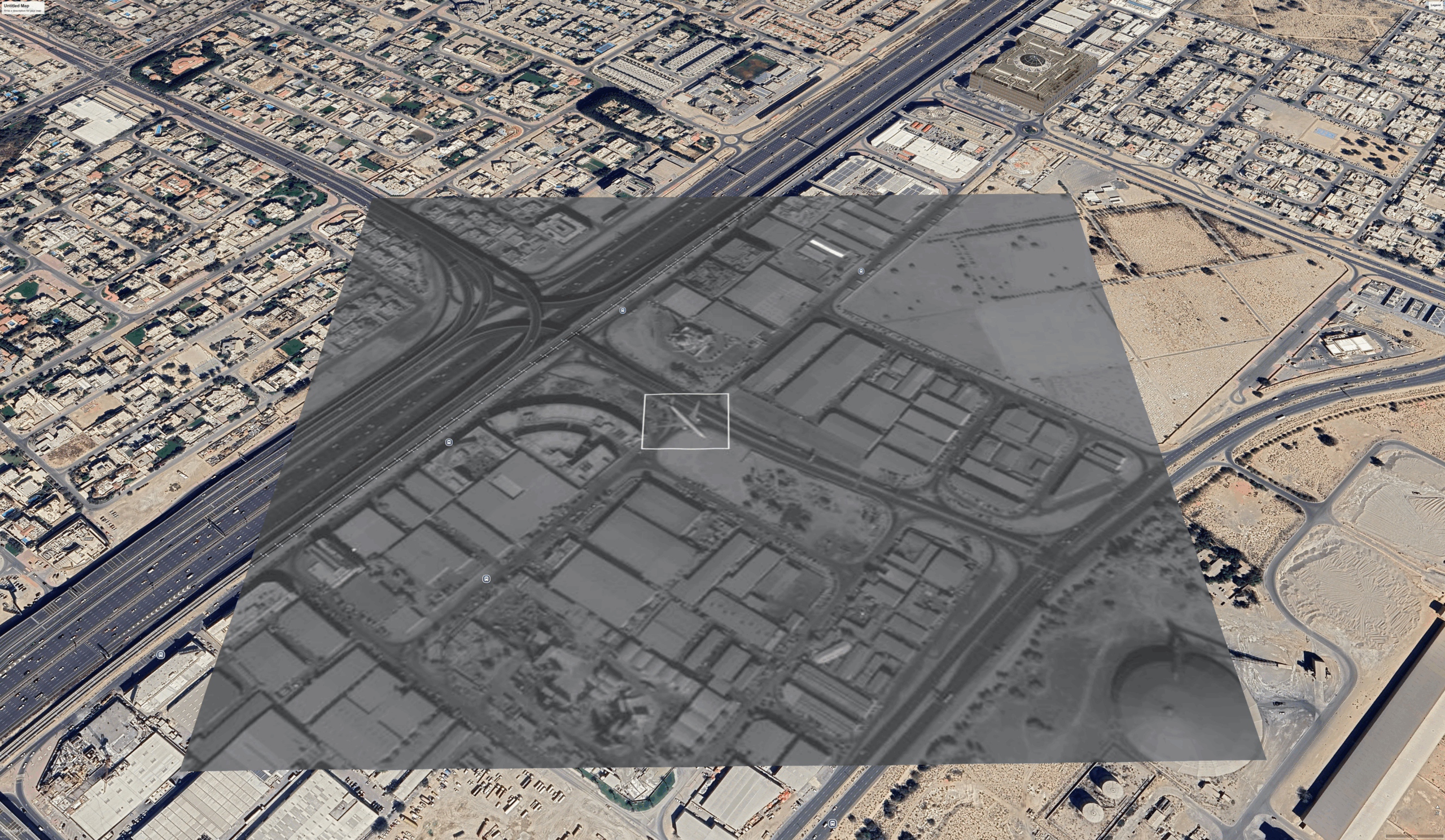
Example of result: A still image of a geolocated moving airplane kmz file using Google Earth. Airplane detected in the vicinity of Dubai. Data reduced 20 000 times in real-time and downlinked as geolocated kmz information. Courtesy of SaraniaSat.
The Demonstration
Instead of waiting for raw imagery to trickle back to Earth, our consortium deployed SaraniaSat’s Moving Target Identification application—packaged as a Kubernetes pod for the BBI dacreo apto spacestack—onto a k3s cluster on HPE’s Spaceborne Computer-2. Full-resolution MAXAR WorldView-3 images were uplinked to the ISS, processed in real time, and only the geolocated overlays were downlinked, delivering near-real-time visibility of flying airplanes.
20 000× Data Reduction: 1.5 GB raw → ~75 kB KMZ overlay
11.7 million× Reduction for Coordinates: 1.5 GB raw → 128 B coordinate packet
Low Latency: Results available in seconds, not hours
Broad Reach: Lightweight packets can be sent via any satcom channel or even direct to devices (e.g. 6G/5G/Bluetooth networks)
This flow—from a git commit on Earth to a container running in orbit—demonstrates that DevOps practices can bridge the terrestrial cloud and the “space cloud” seamlessly.
Observe, reason, and act immediately
Predicting future events in space depends on three streams of knowledge: the historical data we’ve already collected, timely Earth-based intelligence uplinked to the asset, and real-time information from other orbiting platforms. Sorting through these vast volumes of sensor, imagery, and telemetry data—then communicating the distilled insights in standardized formats—is what makes true multi-domain operations (MDO), global command & control, and data-driven business models possible.
Google Earth video of a detection using SaraniaSat’s Moving Target ID intelligence application packaged as a dacreo apto container. Courtesy of SaraniaSat.
Why It Matters
Processing data in orbit slashes both latency and bandwidth costs, enabling truly responsive, time-critical applications. Earth‑observation firms can iterate algorithms in days instead of months; defense agencies gain rapid situational awareness; commercial operators can explore new, rapid service‑based models—subscription analytics, pay‑per‑use compute, even microservices marketplaces—without reinventing legacy space infrastructure.
Civilian Uses: Rapid disaster mapping, environmental monitoring, agricultural insights, and media coverage—all benefit from real-time data.
Business Opportunity: The global space on-board computing market was USD 1.6 billion in 2023 and is forecast to grow at double-digit rates through 2030. By enabling edge compute in orbit, we unlock subscription analytics, pay-per-use compute, and in-orbit microservices marketplaces—new revenue models for government and commercial operators alike.
“This demo on Spaceborne Computer‑2 proves that containerized AI/ML workloads can run reliably in orbit. By integrating with BruhnBruhn’s dacreo apto and SaraniaSat’s pod, we’re extending our ‘Hardening With Software’ strategy to hybrid‑cloud architectures spanning cubesats to large stations.”
Norm Follett, Director, HPE Space Technologies & Services
“Real‑time moving‑target ID from space has long been a tantalizing goal for SaraniaSat. Validating our TensorFlow+ENVI pipeline on orbit shows that indeed Kubernetes‑native DevOps can achieve the promised delivery of mission‑critical insights with unprecedented speed.”
Dr Tom George, CEO, SaraniaSat
“Connecting ground and space through cloud‑native workflows is our vision. Seeing our spacestack thrive under the harshest conditions proves that software‑defined infrastructure is key to the next era of space services.”
Dr Fredrik Bruhn, CTO, BruhnBruhn Innovation
“By leveraging NV5’s ENVI analytics on‑orbit, we enable customers to turn raw imagery into actionable intelligence almost instantly—whether it’s civilian environmental monitoring or defense operations.”
“Utilizing cloud-native solutions combined with secure and reliable networking ensures data integrity and availability end‑to‑end, from ground stations to the ISS. Proving that this is a viable solution in space as well as on earth unlocks unlimited flexibility and building on existing technologies means that the threshold for developing services for space is lowered massively.”
Mattias Ahnberg, CIO & Head of Security, Netnod
About the Partners
HPE: Provider of Spaceborne Computer‑2 by Hewlett Packard Enterprise, enabling high‑performance, space‑qualified compute.
SaraniaSat: Innovator in High Performance Edge Computing for Moving‑Target Identification, ISR and Early Warning of Crop Stress for Precision Agriculture.
NV5 Geospatial Software: Developer of ENVI, the industry’s leading geospatial analytics platform for advanced image processing and ML‑driven feature extraction.
Netnod: Provider of Internet Exchange, communication solutions, DNS-services, time- as well as security services. With a 100% uptime track record on their IX and DNS platforms for more than 20 years they are true experts in building robustness and creating rock-solid solutions.
BruhnBruhn Innovation: Creator of radiation‑hardened, Kubernetes‑compatible infrastructure—and the dacreo apto spacestack that powers cloud‑native computing in orbit.